|


| |
 The
landforms found along a coast may be divided into two types, erosional and
depositional, depending on whether erosion or deposition dominates. Which
process dominates is determined largely by the strength of the local water
conditions. In regions where wave or current activity is strong, erosion
dominates. The water's movement keeps the sand grains in constant motion, and
the longshore drift is strong. In regions where wave and current activity is
weak, sediment cannot be kept suspended, and deposition occurs-that is, the
grains settle to the bottom and remain there. The
landforms found along a coast may be divided into two types, erosional and
depositional, depending on whether erosion or deposition dominates. Which
process dominates is determined largely by the strength of the local water
conditions. In regions where wave or current activity is strong, erosion
dominates. The water's movement keeps the sand grains in constant motion, and
the longshore drift is strong. In regions where wave and current activity is
weak, sediment cannot be kept suspended, and deposition occurs-that is, the
grains settle to the bottom and remain there.
Erosional Landforms
 Waves
are the major eroding agent along the seashore. The force of a wave breaking
against a rocky shore is as strong as a hammer blow. This impact can push water
deep into cracks in a rock face, widening the cracks and loosening rock
fragments that then fall away from the rock. Sand grains carried back and forth
over the rock surface by the wave motion may also erode the rock. The moving
grains rub against the rock like sandpaper, slowly removing small pieces that
are carried away by the longshore drift. Some rock material, such as limestone,
erodes by dissolving into the seawater just as a cube of sugar dissolves into
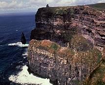
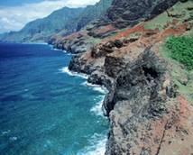
tea, only much more slowly. A common type of erosional landform is a sea cliff,
which usually marks the seaward edge of a coast. Waves
are the major eroding agent along the seashore. The force of a wave breaking
against a rocky shore is as strong as a hammer blow. This impact can push water
deep into cracks in a rock face, widening the cracks and loosening rock
fragments that then fall away from the rock. Sand grains carried back and forth
over the rock surface by the wave motion may also erode the rock. The moving
grains rub against the rock like sandpaper, slowly removing small pieces that
are carried away by the longshore drift. Some rock material, such as limestone,
erodes by dissolving into the seawater just as a cube of sugar dissolves into
tea, only much more slowly. A common type of erosional landform is a sea cliff,
which usually marks the seaward edge of a coast.
Sea Cliff Erosion
 The
erosion associated with wave motion may carve new structures from a sea cliff.
Waves first attack the base of a cliff, slowly cutting out a notch at sea level
and creating an overhanging wave-cut cliff. Slowly the notch is cut more deeply
into the base of the cliff, and eventually the overhanging portion of the cliff
collapses. The fallen debris is broken apart and carried away by the waves. As
this process of undercutting is repeated, the cliff retreats, leaving in its
place a wave-cut platform, a gently sloping surface that extends into the sea.
The debris carried away from the base of the cliff is deposited in deeper water
and eventually it builds a nearly level, submerged surface of loose material
called a wave-built terrace. The
erosion associated with wave motion may carve new structures from a sea cliff.
Waves first attack the base of a cliff, slowly cutting out a notch at sea level
and creating an overhanging wave-cut cliff. Slowly the notch is cut more deeply
into the base of the cliff, and eventually the overhanging portion of the cliff
collapses. The fallen debris is broken apart and carried away by the waves. As
this process of undercutting is repeated, the cliff retreats, leaving in its
place a wave-cut platform, a gently sloping surface that extends into the sea.
The debris carried away from the base of the cliff is deposited in deeper water
and eventually it builds a nearly level, submerged surface of loose material
called a wave-built terrace.
Sometimes a cliff retreats unevenly because of differences in the strength of
the rock and the exposure to the waves. Portions of the cliff that are more
resistant to erosion retreat more slowly and become headlands, which protrude
into the sea. The portions of the cliff that retreat faster give rise to small
inlets and bays between the headlands. Within the bays, the wave activity may
diminish enough to allow sediment to accumulate near the base of the cliff to
form a beach. Such beaches are typically very short and narrow. Often they are
exposed only during low tide, and the water's edge meets the cliff face during
high tide.
In places where the rock is weak or the waves are strong, wave action can hollow
out depressions in a cliff wall that grow into sea caves. Because a headland is
subject to wave action on two sides, caves dug from both sides may eventually
meet in the middle, cutting a tunnel through the headland. Further erosion will
widen the tunnel, eventually leaving behind only an overlying rock bridge called
a sea arch. Continued erosion eventually causes the arch to collapse, leaving an
isolated column of rock, called a sea stack, in front of the headland.
Under the relentless pounding of the waves, headlands, caves, arches and stacks
are continually formed and destroyed as a cliff retreats inland. At the same
time, the wave-cut platform and the wave-built terrace grow wider. As the waves
travel across the resulting region of shallow water, they grow weaker as a
result of friction with the bottom. With weaker waves, the erosion of the cliff
face slows and beaches may begin to develop against the base of the cliff.
Interrupted Erosion
 The
evolution of a shoreline by erosion may be interrupted by tectonic uplift, or a
sudden movement of Earth's crust, which lifts a coastal region. Once lifted
above the sea, the former beaches, wave-cut platforms, and wave-built terraces
become a new coastal plain. The process of erosion begins again as wave action
attacks the new coastline. The
evolution of a shoreline by erosion may be interrupted by tectonic uplift, or a
sudden movement of Earth's crust, which lifts a coastal region. Once lifted
above the sea, the former beaches, wave-cut platforms, and wave-built terraces
become a new coastal plain. The process of erosion begins again as wave action
attacks the new coastline.
Depositional Landforms
In areas along a coast where deposition is
dominant, the
shoreline is formed by the accumulation of sediment rather than by its removal.
Several coastal landforms are characteristic of deposition, such as river deltas,
tombolos, spits and hooks, barrier islands, sandbars, and tidal flats.
River Deltas
Deposition occurs most persistently at a river delta-a
roughly triangular region at the mouth of a river where the river deposits
sediment. As the river travels along its course, it collects sediment. The
amount of sediment that a river carries depends on the speed of the river's
current-faster current speeds enable the river to carry more sediment. As the
river arrives at the coast and flows into the sea, its current slows drastically,
dropping below the speed required to carry the river's load of sediment. The
sediment then settles to the bottom, forming a delta.
Continued deposition over decades builds up the bottom at a river's mouth,
slowly raising the level of the bottom there. However, the increasing weight of
the sediment accumulating in the delta over hundreds of years causes the delta
to subside, or sink with respect to surrounding land regions. As a model for
subsidence, consider an air mattress floating in a swimming pool. When a person
gets on the mattress, thus increasing the weight carried by the mattress, the
mattress sinks deeper into the water. Similarly, as sediment accumulates near a
river's mouth, the delta region carries increasing weight and, like the mattress,
sinks downward.
Subsidence is gradual, often proceeding at a rate comparable to the rate of
deposition. For example, the delta of the Mississippi River is subsiding at a
rate of about 1 cm (0.4 in) per year. At this rate the height of the delta above
sea level remains nearly constant over a long period.
Tombolos
Away from the mouths of rivers, deposition also occurs
wherever wave activity is weak. For example, a small island close to shore
shelters the mainland shoreline from strong ocean waves, thus diminishing wave
activity between the island and the mainland. This region is called a wave
shadow zone. The longshore drift cannot pass through this quiet region because
wave motion is needed to maintain longshore drift. Therefore, any sediment
carried by longshore drift into such an area is deposited there. The deposition
of sediment eventually builds up a sand bridge that connects the island to the
mainland. The sand bridge is called a tombolo.
Spits and Hooks
Deposition from longshore drift also forms sandy extensions
of a beach, called spits and hooks. A spit stretches partway across the mouth of
a cove or a bay. When the longshore drift traveling along a beach meets a cove
or a bay, the path of the drift carries the drift into deeper water. However, as
the water deepens, the wave activity at the bed decreases and the drift cannot
be maintained. The drift's sediment is then deposited, forming a spit. Once a
spit forms, wave action remains strong on the seaward side of the spit, and the
longshore drift continues to transport sediment to the end of the spit, where it
is deposited. The spit protects the bay from ocean waves, creating a shadow zone
of calm water on its landward side. Deposition in the shadow zone at the end of
the spit can cause the spit to turn landward and form a hook.
Barrier Islands
 A
mainland shoreline may also be protected from ocean waves by barrier islands,
which are long, narrow islands running parallel to the mainland shore. A shallow
bay, sometimes called a lagoon, separates barrier islands from the mainland. A
barrier island may have formed as a spit, or as a sand dune that has since been
drowned by rising sea levels. Barrier islands tend to migrate, as a result of
the action of wind and/or water. A
mainland shoreline may also be protected from ocean waves by barrier islands,
which are long, narrow islands running parallel to the mainland shore. A shallow
bay, sometimes called a lagoon, separates barrier islands from the mainland. A
barrier island may have formed as a spit, or as a sand dune that has since been
drowned by rising sea levels. Barrier islands tend to migrate, as a result of
the action of wind and/or water.
Tidal Flats
Along protected stretches of a coastline where wave activity
is extremely weak, very fine particles, such as clay and silt, are deposited,
forming tidal flats. A tidal flat is a wide and nearly level region of land that
is covered by water during high tides but exposed to the air during low tide.
Most of the particles that are deposited there simply settle out of the nearly
still water.
|